


M2P
Product description
● Application of GPS technology, can carry out all-round monitoring of buoy: location and trajectory, buoy damage monitoring, the time arrived at the buoy to estimate.
● In 50 miles, buoy power information transmitted by wireless encrypted information and battery.
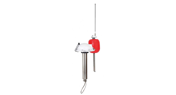
● it includes a GPS receiver, an antenna by charging the battery main body is made of stainless steel, magnetic switch, flash position hint, color LED (operating tips) and antenna.
● The temperature sensor can be selected.
operation
● every 5, 10 or 15 minutes, a M2P transmits encrypted information, the information is only the M2P client can receive and interpret.
● The ship through the MIR-2200 system to send buoy instructions, the system can be connected to the ship's receiver or telephone system.
● MSB-PALANGRE (surface longline) and MSB-CACEA (point longline) management program can automatically set two buoys, buoy position is displayed in the C-MAP chart.
Characteristic
● The range of up to 50 miles.
● It doesn't have the communication cost (using radio communication).
● through the monitoring of the fishing line, reduce the labor intensity of the ship staff, save fuel.
● Flash location hints: this function allows the operator to easily find buoy.
● The LED instructions.
● The GPS location and power tips.
● optional temperature measurement.
● Security: information encryption transmission.
● Can be through the antenna charging the battery (battery can be used for 8 days).
● The main - buoy is tubular, more easily in the limited space on the ship to store.


technical parameter
● Buoy - weight: 1.3KG.
● The tube body weight: 2.8KG.
● Power: rechargeable battery.
● Working temperature: - 0 DEG -50 deg.
● size: reference drawings.

-
Products
-
Solution
-
Service and support
-
About us

Phone:021 5988 4528
Fax:021-59884028
Email:sales@tpm-marine.com
Address:Longchang Road, Yangpu District, Shanghai619No. City Concept8Building Southern DistrictB11Building Southern District
Copyright © 2015 (Shanghai) Co., Ltd. Ship
ShanghaiicpShanghai...201332089
Sweep the attention
Ma Po special official micro letter
